
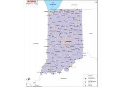
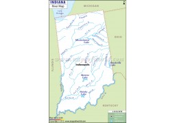
Indiana Zip Code Map - Digital File

- Wish
- Product Description
- Related Products
* These digital maps are for personal or internal use of the organization.
*We offer simple and affordable License for Multiple Use
*Purchased image/map will come without watermarks.- Brand - Maps of World
- Product Code - MOW3027
Digital Map Specification

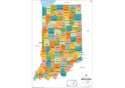
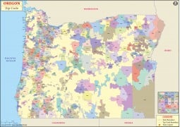
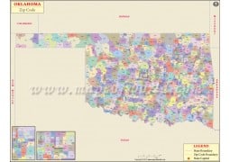
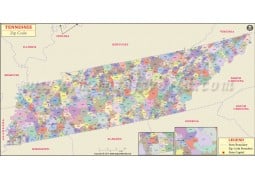
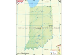
This Zip Code Map of Indiana is designed
to clearly show the distribution of the USPS Zip Codes throughout the state.
With a glance you can see the where any Zip Code lies within the state.
This Indiana Zip Code map is sized at 33" X 46", and is available for direct download. The map image comes in various resolutions and formats; JPG, AI (Adobe Illustrator), EPS and Layered PDF. The JPEG’s are a raster format, and the AI, EPS, and Layered PDF formats are vector files, and can are editable and can be customized.
This map is sized at 33.11" W x 46.73" H. The 72 DPI file is 4972 Pixel wide, and 300 DPI file is 6002 Pixels wide.
-
 $25.00
-
 $25.00
-
 $25.00
-
 $25.00
-
 $25.00
-
 $49.00
-
 $49.00
-
 $49.00
-
 $49.00
-
 $49.00
-
 $49.00
-
 $25.00
-
 $49.00
-
 $49.00
-
 $49.00
-
 $49.00
-
 $29.00
-
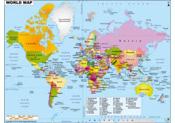
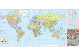
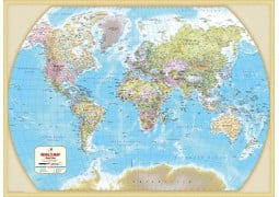
The World Reference Political Map is a multi-colored political map, noting the countries of the world with their interna...
 $12.00
-
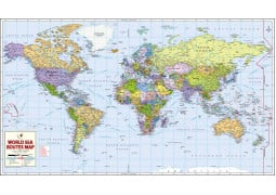
World Sea Routes Map This large World Sea Route Map shows the world’s major sea networks with nautical miles. Thi...
-
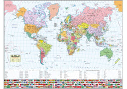
World Map with FlagsThis World Map has been aesthetically designed using the Miller Cylindrical Projection. The map shows the lo...
-
An updated take on our World’s Best World Map, this Large World Map makes great use of space by reducing the amount of the Poles...
-
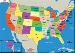
US States and Capitals Map This US States and Capitals Map (US Political Map) shows all of US states and their capital cit...
-
A Physical Map of the US, with political information. Using color and relief to represent elevation, this map shows the physi...
 $29.00
-
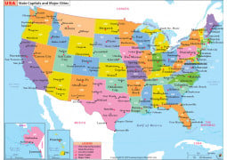
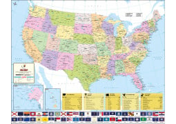
US State Capitals and Major Cities Map This colorful US State Capitals and Major Cities Map clearly shows the layout of all the ...
-
Expertly researched, and packed with information about the United States...this is the World's Best US Map! Edited, researched, an...
-
California State Digital Map ...
-
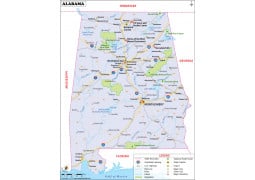
This Reference Map of Alabama, shows the major transportation routes through the 'Heart of Dixie.' The map notes the primary citie...
-
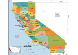
California County Map This California County Map shows the state and it’s 58 counties. Each county is color codes for easy identi...
-
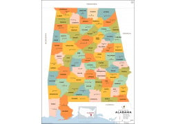
This Alabama County Map shows the state and it’s 67 counties. Each county is color codes for easy identification. All county an...

-
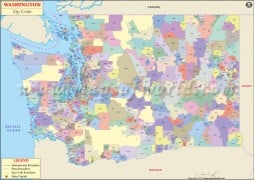
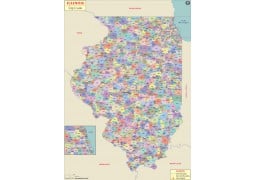
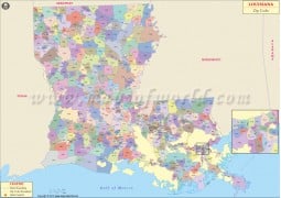
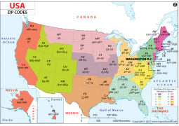
About US Zip Code Map The U S Zip code map shows the United States Zip Code zones. ZIP codes are numbered with the first di...
-
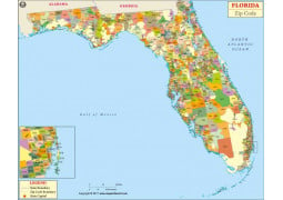
This Zip Code Map of Florida is designed to clearly show the distribution of the USPS Zip Codes throughout the state. With a gla...
-
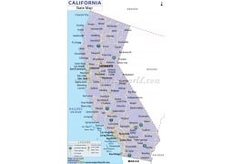
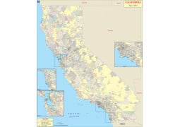
This Zip Code Map of California is designed to clearly show the distribution of the USPS Zip Codes throughout the state. With a ...
-
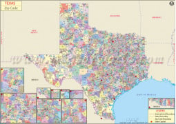
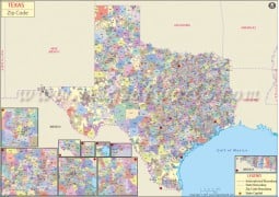
Texas Zip Code Map A map of the Lone Star State, showing the 2,600 Zip Codes across the state. inset maps are included for the to...
-
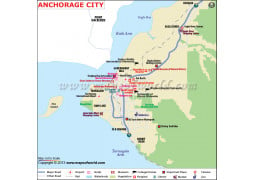
Anchorage City Digital Map ...
-
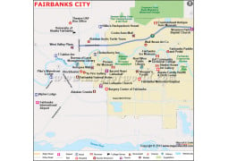
Fairbanks City Digital Map ...
-
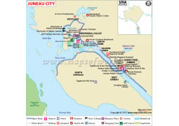
Juneau City Digital Map ...
-
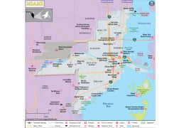
One of the cultural capitals of the US, Miami, Florida is dripping with international flair. This clear overview map shows the pr...


-
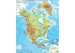
This North American Physical Map, highlights the primary physical features across North America. The map includes all the area on ...
-
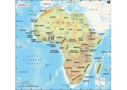
Africa Continent Digital MapSize of the map : 72 DPI file is 1200 Pixel wide and 300 DPI file is 4406 Pixel wide, height o...
-
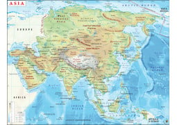
This continent map of Asia shows the distribution of Asian countries, their international borders, continent boundaries and...
 $29.00
-
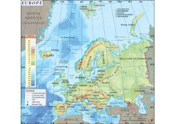
Europe MapThis Map of Europe shows the entire continent, and all the nations along with their capitals. The map shows the p...
 $29.00
-
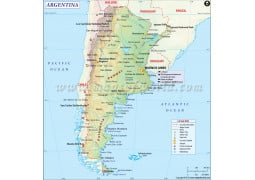
Argentina Country Digital Map ...
 $29.00
-
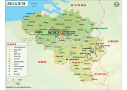
Belgium Country Digital Map ...
 $29.00
-
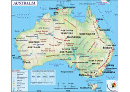
This Australia map is a highly detailed Physical Map, illustrating the physical features of the continent. It also some the polit...
 $29.00
-
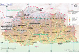
Bhutan Map ...
 $29.00
-
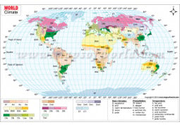
This Climate Map of the World illustrates the various climatic types in the world. The map marks the various regions of the wor...
-
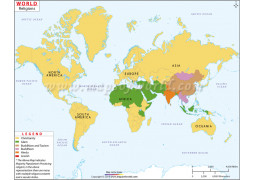
About World Religion Map The Religion Map of the World, as the name suggests provide information about the major relig...
-
Size of the map : 72 DPI file is 1200 Pixel wide and 300 DPI file is 3223 Pixel wide, height of the map is proportional to widt...
-
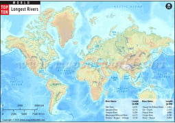
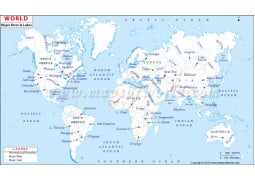
About World River Map World river map depicts all major rivers & lakes of the world on the map with their names. The&nb...
-
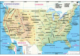
USA Road Map A detailed road map of the USA. Includes State highways, Federal highways, Interstate highways, all with road...
-
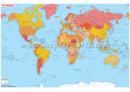
About World Political Map with Cities This World Political Map shows each country in bright colors with clear demarcati...
-
World Map with FlagsThis World Map has been aesthetically designed using the Miller Cylindrical Projection. The map shows the lo...
-
About Large World Map with Cities Size : 60X39 Inch or 5 feet wide and 3.3 feet high. Formats : 72 and 300 DP...
-
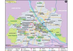
Vienna City Digital Map ...
 $39.00
-
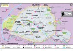
Reasons to Buy Paris Map Paris Map covers all major tourist attractions of the famous city, Apart from major travel attract...
 $39.00
-
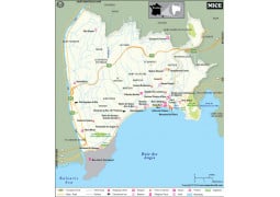
Nice, France, a highly visited city in the south of France. This clear overview map shows the primary routes throughout the city...
 $29.00
-
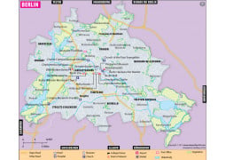
Considered by many as the ‘new capital,’ of Europe, this map of Berlin, Germany is a clear overview map shows the primary routes...
-
USA Road Map A detailed road map of the USA. Includes State highways, Federal highways, Interstate highways, all with road...
-
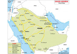
This Road Map of Saudi Arabia is a simple map showing the national road network of the country. The notes primary and secondary c...
-
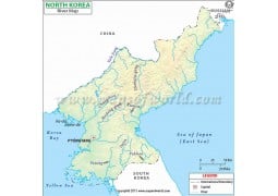
The most closed county in the world, our North Korea Road Map, shows the network of the primary transportation system of North K...
-
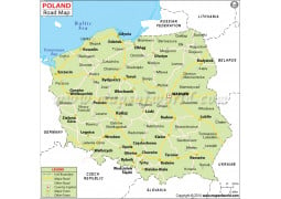
Poland Road Map ...
-
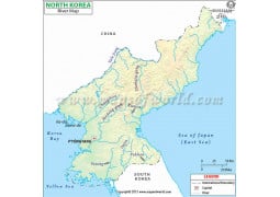
North Korea River Digital Map ...
-
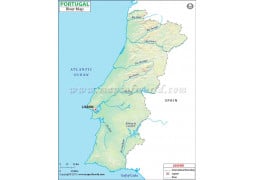
Portugal River Digital Map ...
-
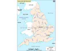
England River Map ...
-
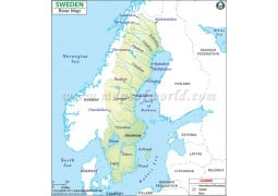
River Map of Sweden ...


-
Europe Political Map in Portuguese ...
-
About World Map in French (Carte De Monde) It is a brightly colored World Map with text given in French. This descriptive W...
-
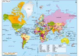
About Arabic Language World Map Width of 72 DPI resolution arabic world map is 2000PX and height as proportional to wi...

-
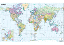
The World Reference Political Map is a multi-colored political map, noting the countries of the world with their international bou...
$49.95
-
World Sea Routes Map World Sea Route Map shows the world’s major sea networks with nautical miles.This det...
 $39.95
-
World Map with Flags This World Map has been aesthetically designed using the Miller Cylindrical Projection. The map shows the ...
 $39.95
-
World Map With Major Cities "Utilizing the view of the Van der Grinten Projection, the World Map with Major Cities shows the l...
 $49.95
-
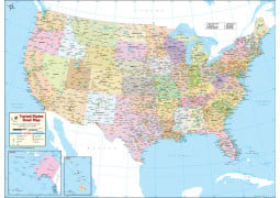
US States and Capitals Map This US States and Capitals Map (US Political Map) shows all of US states and their capital cities....
 $49.95
-
Printed USA Map This is a highly detailed all-purpose map of the USA showing location of all the states, cit...
$49.95
-
US State Capitals and Major Cities MapThis colorful US State Capitals and Major Cities Map clearly shows the layout of all the Sta...
-
Expertly researched, and packed with information about the United States...this is the World's Best US Map! Edited, researched, an...
 $49.95

-
This Reference Map of Alabama, shows the major transportation routes through the 'Heart of Dixie.' The map notes the primary cit...
 $49.95
-
This Alabama County Map shows the state and it’s 67 counties. Each county is color codes for easy identification. All county and s...
 $49.95
-
 $49.95
-
This California County Map shows the state and it’s 58 counties. Each county is color codes for easy identification. All county, s...
 $49.95
-
 $49.95
-
This Zip Code Map of Florida is designed to clearly show the distribution of the USPS Zip Codes throughout the state. With a gla...
 $49.95
-
This Zip Code Map of California is designed to clearly show the distribution of the USPS Zip Codes throughout the state. With a ...
 $49.95
-
A map of the Lone Star State, showing the 2,600 Zip Codes across the state. inset maps are included for the to better visualize th...
 $49.95
-
 $49.95
-
 $49.95
-
 $49.95
-
One of the cultural capitals of the US, Miami, Florida is dripping with international flair. This clear overview map shows the pr...
 $49.95
-
 $49.95
-
The map of Asia The map of Asia shows the location of the countries in the continent. The neighboring cont...
$49.95
-
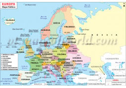
This Map of Europe shows the entire continent, and all the nations along with their capitals. The map shows the physical make-...
$49.95
-
This North American Physical Map, highlights the primary physical features across North America. The map includes all the area o...
 $49.95
-
 $49.95
-
 $49.95
-
The Bhutan map is a general map of the country showing both the physical and political features. The map preci...
 $49.95
-
This Australia Physical Map illustrates the physical features of the continent along with the political division of the six states...
$49.95
-
 $49.95
-
 $49.95
-
 $49.95

-
USA Road Map A detailed road map of the USA. Includes State highways, Federal highways, Interstate highways, all with ro...
 $49.95
-
World Map with Flags This World Map has been aesthetically designed using the Miller Cylindrical Projection. The map shows the ...
$39.95
-
 $49.95
-
 $49.95
-
Considered by many as the ‘new capital,’ of Europe, this map of Berlin, Germany is a clear overview map shows the primary routes...
 $49.95
-
 $49.95
-
Nice, France, a highly visited city in the south of France. This clear overview map shows the primary routes throughout the city, ...
$49.95
-
USA Road Map A detailed road map of the USA. Includes State highways, Federal highways, Interstate highways, all with ro...
$49.95
-
The most closed county in the world, our North Korea Road Map, shows the network of the primary transportation system of North Kor...
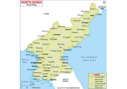 $49.95
-
 $49.95
-
This Road Map of Saudi Arabia is a simple map showing the national road network of the country. The notes primary and secondary c...
 $49.95
-
 $49.95
-
 $49.95
-
 $49.95
-
 $49.95
-
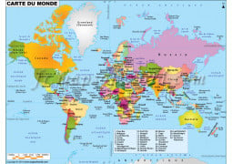
World Map in French-Carte De Monde It is a brightly colored World Map with text given in French. This descriptive World Map...
-
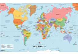
Our Spanish World Map is an updated world political map with each countries name written in the Spanish language. A popular and us...
 $49.95


-
Vivid colors and detailing bring the world alive! The beauty of this world map lies in its updated accuracy and bold colors. Using...

