
India Political Map - Digital File

- Wish
- Product Description
- Related Products
* These digital maps are for personal or internal use of the organization.
*We offer simple and affordable License for Multiple Use
*Purchased image/map will come without watermarks.- Brand - Maps of World
- Product Code - MOW1070
Digital Map
Formats to Buy/Download
Digital Map Specification

Specification & Review
Reasons to Buy India Political Map
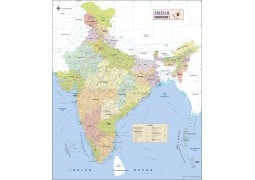
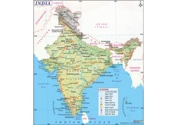
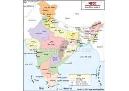
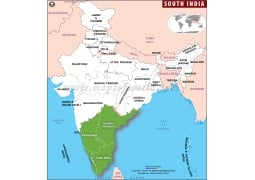
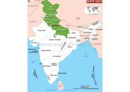
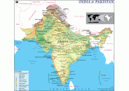
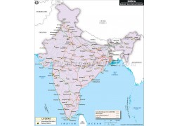
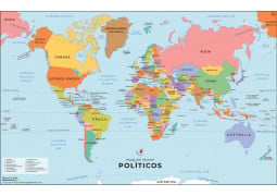
India Political Map portrays states in different colors demarcated with state boundaries. Names of capital cities, country capital New Delhi along with the neighboring countries Pakistan, Bangladesh, China, Nepal etc. are also shown on the map. Newly made state Telangana also depicted on the map. India Political Map available for purchase in various resolutions and formats such as JPG, AI, EPS and Layered PDF. The AI, EPS and Layered PDF, which are vector formats are editable and can be customized. This map is useful for presentations, project works, general studies, cartographic work and teaching purposes.
-
 $39.00
-
 $25.00
-
 $25.00
-
 $25.00
-
 $25.00
-
 $29.00
-
 $25.00
-
 $25.00
-
 $25.00
-
 $25.00
-
 $25.00
-
 $25.00
-
 $25.00
-
 $25.00
-
 $25.00
-
 $25.00
-
 $25.00
-
 $25.00
-
 $25.00
-
 $25.00
-
 $25.00
-
 $25.00
-
 $25.00
-
 $25.00
-
 $25.00
-
 $25.00
-
 $25.00
-
 $25.00
-
 $25.00
-
 $25.00
-
 $29.00
-
 $25.00
-
 $25.00
-
 $25.00
-
 $25.00
-
 $25.00
-
 $25.00
-
 $25.00
-
 $25.00
-
 $25.00
-
 $25.00
-
 $25.00
-
 $25.00
-
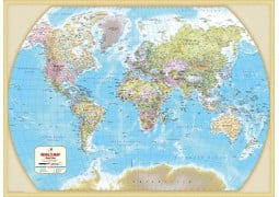
The World Reference Political Map is a multi-colored political map, noting the countries of the world with their interna...
 $12.00
-
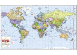
World Sea Routes Map This large World Sea Route Map shows the world’s major sea networks with nautical miles. Thi...
-
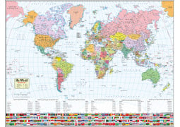
World Map with FlagsThis World Map has been aesthetically designed using the Miller Cylindrical Projection. The map shows the lo...
-
An updated take on our World’s Best World Map, this Large World Map makes great use of space by reducing the amount of the Poles...
-
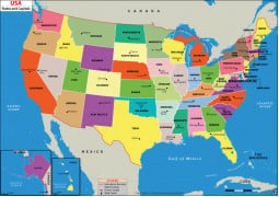
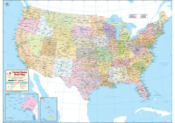
US States and Capitals Map This US States and Capitals Map (US Political Map) shows all of US states and their capital cit...
-
A Physical Map of the US, with political information. Using color and relief to represent elevation, this map shows the physi...
 $29.00
-
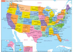
US State Capitals and Major Cities Map This colorful US State Capitals and Major Cities Map clearly shows the layout of all the ...
-
Expertly researched, and packed with information about the United States...this is the World's Best US Map! Edited, researched, an...
-
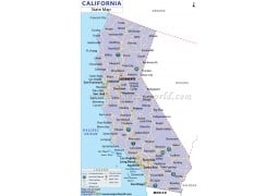
California State Digital Map ...
-
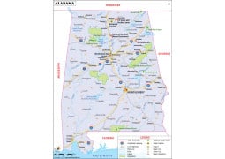
This Reference Map of Alabama, shows the major transportation routes through the 'Heart of Dixie.' The map notes the primary citie...
-
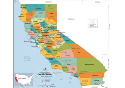
California County Map This California County Map shows the state and it’s 58 counties. Each county is color codes for easy identi...
-
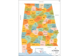
This Alabama County Map shows the state and it’s 67 counties. Each county is color codes for easy identification. All county an...

-
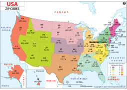
About US Zip Code Map The U S Zip code map shows the United States Zip Code zones. ZIP codes are numbered with the first di...
-
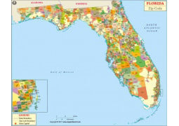
This Zip Code Map of Florida is designed to clearly show the distribution of the USPS Zip Codes throughout the state. With a gla...
-
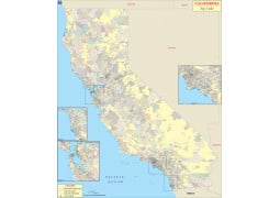
This Zip Code Map of California is designed to clearly show the distribution of the USPS Zip Codes throughout the state. With a ...
-
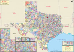
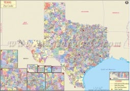
Texas Zip Code Map A map of the Lone Star State, showing the 2,600 Zip Codes across the state. inset maps are included for the to...
-
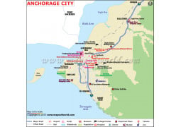
Anchorage City Digital Map ...
-
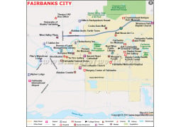
Fairbanks City Digital Map ...
-
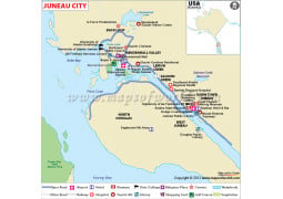
Juneau City Digital Map ...
-
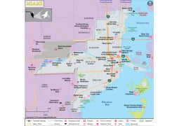
One of the cultural capitals of the US, Miami, Florida is dripping with international flair. This clear overview map shows the pr...


-
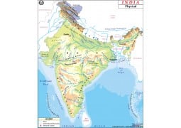
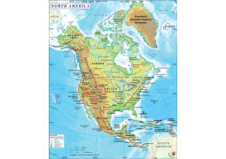
This North American Physical Map, highlights the primary physical features across North America. The map includes all the area on ...
-
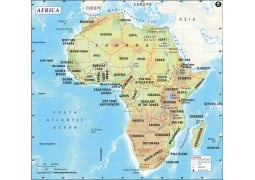
Africa Continent Digital MapSize of the map : 72 DPI file is 1200 Pixel wide and 300 DPI file is 4406 Pixel wide, height o...
-
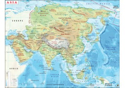
This continent map of Asia shows the distribution of Asian countries, their international borders, continent boundaries and...
 $29.00
-
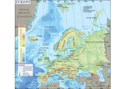
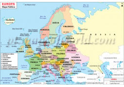
Europe MapThis Map of Europe shows the entire continent, and all the nations along with their capitals. The map shows the p...
 $29.00
-
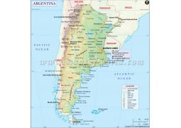
Argentina Country Digital Map ...
 $29.00
-
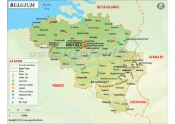
Belgium Country Digital Map ...
 $29.00
-
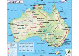
This Australia map is a highly detailed Physical Map, illustrating the physical features of the continent. It also some the polit...
 $29.00
-
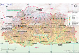
Bhutan Map ...
 $29.00
-
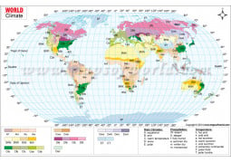
This Climate Map of the World illustrates the various climatic types in the world. The map marks the various regions of the wor...
-
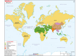
About World Religion Map The Religion Map of the World, as the name suggests provide information about the major relig...
-
Size of the map : 72 DPI file is 1200 Pixel wide and 300 DPI file is 3223 Pixel wide, height of the map is proportional to widt...
-
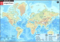
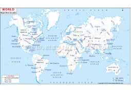
About World River Map World river map depicts all major rivers & lakes of the world on the map with their names. The&nb...
-
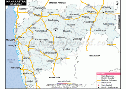
USA Road Map A detailed road map of the USA. Includes State highways, Federal highways, Interstate highways, all with road...
-
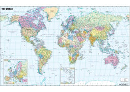
About World Political Map with Cities This World Political Map shows each country in bright colors with clear demarcati...
-
World Map with FlagsThis World Map has been aesthetically designed using the Miller Cylindrical Projection. The map shows the lo...
-
About Large World Map with Cities Size : 60X39 Inch or 5 feet wide and 3.3 feet high. Formats : 72 and 300 DP...
-
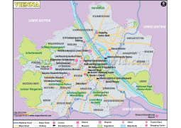
Vienna City Digital Map ...
 $39.00
-
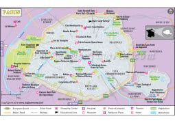
Reasons to Buy Paris Map Paris Map covers all major tourist attractions of the famous city, Apart from major travel attract...
 $39.00
-
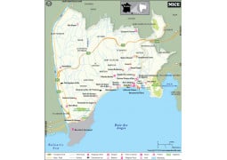
Nice, France, a highly visited city in the south of France. This clear overview map shows the primary routes throughout the city...
 $29.00
-
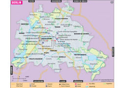
Considered by many as the ‘new capital,’ of Europe, this map of Berlin, Germany is a clear overview map shows the primary routes...
-
USA Road Map A detailed road map of the USA. Includes State highways, Federal highways, Interstate highways, all with road...
-
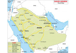
This Road Map of Saudi Arabia is a simple map showing the national road network of the country. The notes primary and secondary c...
-
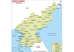
The most closed county in the world, our North Korea Road Map, shows the network of the primary transportation system of North K...
-
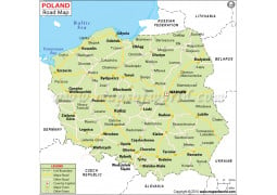
Poland Road Map ...
-
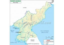
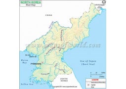
North Korea River Digital Map ...
-
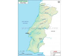
Portugal River Digital Map ...
-
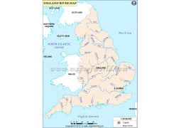
England River Map ...
-
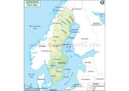
River Map of Sweden ...


-
Europe Political Map in Portuguese ...
-
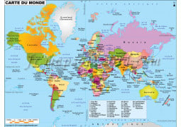
About World Map in French (Carte De Monde) It is a brightly colored World Map with text given in French. This descriptive W...
-
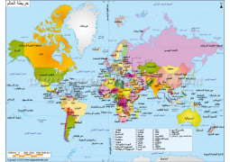
About Arabic Language World Map Width of 72 DPI resolution arabic world map is 2000PX and height as proportional to wi...

-
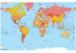
The World Reference Political Map is a multi-colored political map, noting the countries of the world with their international bou...
$49.95
-
World Sea Routes Map World Sea Route Map shows the world’s major sea networks with nautical miles.This det...
 $39.95
-
World Map with Flags This World Map has been aesthetically designed using the Miller Cylindrical Projection. The map shows the ...
 $39.95
-
World Map With Major Cities "Utilizing the view of the Van der Grinten Projection, the World Map with Major Cities shows the l...
 $49.95
-
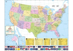
US States and Capitals Map This US States and Capitals Map (US Political Map) shows all of US states and their capital cities....
 $49.95
-
Printed USA Map This is a highly detailed all-purpose map of the USA showing location of all the states, cit...
$49.95
-
US State Capitals and Major Cities MapThis colorful US State Capitals and Major Cities Map clearly shows the layout of all the Sta...
-
Expertly researched, and packed with information about the United States...this is the World's Best US Map! Edited, researched, an...
 $49.95

-
This Reference Map of Alabama, shows the major transportation routes through the 'Heart of Dixie.' The map notes the primary cit...
 $49.95
-
This Alabama County Map shows the state and it’s 67 counties. Each county is color codes for easy identification. All county and s...
 $49.95
-
 $49.95
-
This California County Map shows the state and it’s 58 counties. Each county is color codes for easy identification. All county, s...
 $49.95
-
 $49.95
-
This Zip Code Map of Florida is designed to clearly show the distribution of the USPS Zip Codes throughout the state. With a gla...
 $49.95
-
This Zip Code Map of California is designed to clearly show the distribution of the USPS Zip Codes throughout the state. With a ...
 $49.95
-
A map of the Lone Star State, showing the 2,600 Zip Codes across the state. inset maps are included for the to better visualize th...
 $49.95
-
 $49.95
-
 $49.95
-
 $49.95
-
One of the cultural capitals of the US, Miami, Florida is dripping with international flair. This clear overview map shows the pr...
 $49.95
-
 $49.95
-
The map of Asia The map of Asia shows the location of the countries in the continent. The neighboring cont...
$49.95
-
This Map of Europe shows the entire continent, and all the nations along with their capitals. The map shows the physical make-...
$49.95
-
This North American Physical Map, highlights the primary physical features across North America. The map includes all the area o...
 $49.95
-
 $49.95
-
 $49.95
-
The Bhutan map is a general map of the country showing both the physical and political features. The map preci...
 $49.95
-
This Australia Physical Map illustrates the physical features of the continent along with the political division of the six states...
$49.95
-
 $49.95
-
 $49.95
-
 $49.95

-
USA Road Map A detailed road map of the USA. Includes State highways, Federal highways, Interstate highways, all with ro...
 $49.95
-
World Map with Flags This World Map has been aesthetically designed using the Miller Cylindrical Projection. The map shows the ...
$39.95
-
 $49.95
-
 $49.95
-
Considered by many as the ‘new capital,’ of Europe, this map of Berlin, Germany is a clear overview map shows the primary routes...
 $49.95
-
 $49.95
-
Nice, France, a highly visited city in the south of France. This clear overview map shows the primary routes throughout the city, ...
$49.95
-
USA Road Map A detailed road map of the USA. Includes State highways, Federal highways, Interstate highways, all with ro...
$49.95
-
The most closed county in the world, our North Korea Road Map, shows the network of the primary transportation system of North Kor...
 $49.95
-
 $49.95
-
This Road Map of Saudi Arabia is a simple map showing the national road network of the country. The notes primary and secondary c...
 $49.95
-
 $49.95
-
 $49.95
-
 $49.95
-
 $49.95
-
World Map in French-Carte De Monde It is a brightly colored World Map with text given in French. This descriptive World Map...
-
Our Spanish World Map is an updated world political map with each countries name written in the Spanish language. A popular and us...
 $49.95


-
Vivid colors and detailing bring the world alive! The beauty of this world map lies in its updated accuracy and bold colors. Using...

